Mt Sahale (Actually - Mt Buckner)
|
Mt Sahale (Actually - Mt Buckner) |
|
|
Tuesday: We had sent off Jean to Seminary Camp at Provo for the week and Jared was on Army maneuvers so it was just the two of us. On Tuesday at about 10am, after packing and getting the cars ready (i.e. nice clean truck for Jean when she gets back), we left for Marblemount ranger station. In a little town called Concrete, we feasted on burgers and really monstrous chocolate shakes. Thank goodness it took a little time to get our backcountry pass at the ranger station as I would never had made it up the trail as stuffed as I was. Outside of Marblemount, we turned off the main road taking a bridge across a aqua-marine river – our 1st |
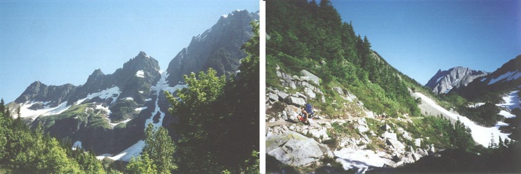
| real sign of the high country awaiting us. 23 miles of smooth dirt road zoomed by. I pressed the envelope to scavenge time as it was now around 3pm. The problem with that was that the rangers orchestrated the campsites and we could not get either of the nearby campsites leaving a very long hike over 8 miles with a couple of thousand feet of both up and back down. We had 50 lbs backpacks and soft bodies to drag up and down that tough trail. At the trail head we were greeted by breathtaking views of horizon to horizon sheer mountain faces, exposed glaciers, thundering waterfalls and thousands – no millions of little devil-flies bent on sucking the very life out of your body. You could hardly tie a shoelace without looking like a spastic madman. These homing swarms nearly drained the enthusiasm for the trip, but a returning hiker noted encouragingly that they were not found at the higher elevations – only their bigger cousins. They did have one therapeutic benefit for the ardor of the unrelenting grade and unending switchbacks – you simply could not stop without being unmercifully chased back to your feet and farther up the trail; and we did hike quickly, despite the load, and arrived to the truly awesome Cascade Pass at around 5PM. Neither Sahale nor Buckner were visible, but great valleys and escarped glacier laden peaks on the east side of the valley filled the view. The Pass itself had a strange park like appearance with a low grass and rock-lined paths; even low log benches graced the mountain’s saddle. We traded pleasantries and commiserations with a few sojourners, recouped our strength a bit and then took the plunge back down the other side of the mountain. | |
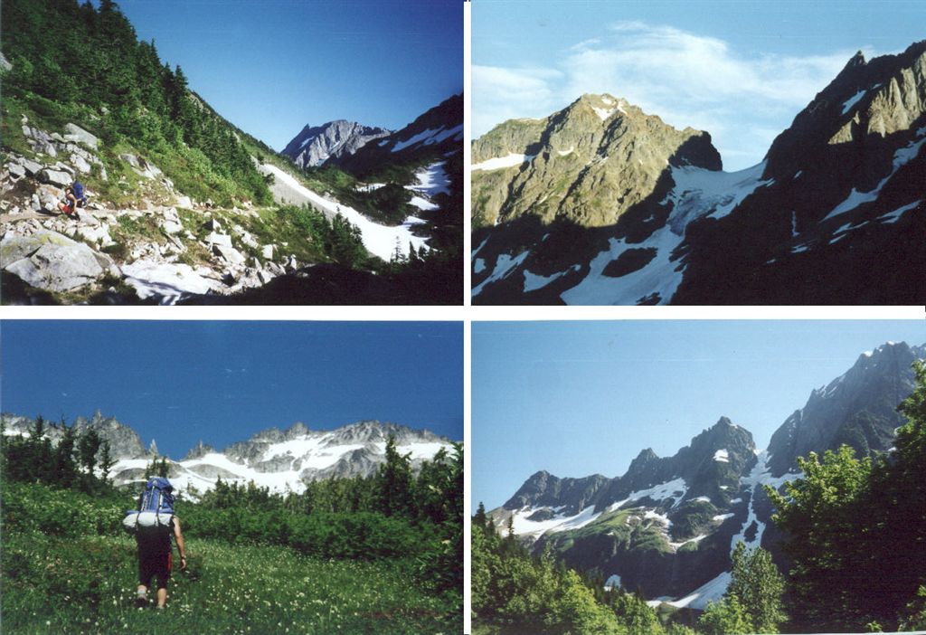 |
| We had less than 3 hours of light and about 4 miles to go, but it was mostly down, so Jordon and I were pretty confidant we would make it before dark. We extended ourselves, trekking a fast pace over a pretty rocky trail and reached a headwall to the valley. At this headwall we could in one expansive view see Sahale to the North, Bucker at NE and the Stenkie valley stretching out before us projecting from a good 1000-foot wall. OUCH. The realization that what ever we dropped we would have to retrace was voiced and grumbled betwixt oohs and ahhs. After numerous switchbacks we crossed a fantastic set of pools created from a waterfall above and below. It was now getting late and the evening shadows grew fast upon us. We talked briefly to a couple of backpackers trying to make the pass. They had to acknowledge the futility and determined to bivouac at the falls. I grew a bit concerned that we were ourselves running precious short on light and yet the trail seemed to stretch out yet before us. Knowing that we would return this way to climb Sahale and wanting to lighten our load, we cached some of our climbing gear in some rocks above the trail. We hurried on. Jordon chided how we should have done that move miles ago; no argument here! Another mile or so and we came to a fork in the trail but the sign only labeled Horseshoe Basin. The other leg seemed like a spur. The name of our camp was Basin Camp, so I figured that the trail branch to Basin camp was yet before us in the direction of Horseshoe Basin. The trail rose sharply to the left and I grumbled “Why?” Jordon figured correctly that that spur back there was most likely the correct route, but I don’t recall the comment. We pressed on up and up as the light drained from the sky. The trail turned into a little stream that we variously sloshed through. We both could tell for sure now that we were heading into the Horseshoe basin and we resolved to push hard with all our waning strength to the foot of the basin wall where the vegetation gave way. We were sure to find some spot to camp there. With only minutes of weak light left we broke free of the overhanging brush and trees and spotted a nearly level flat rock about 15 feet in diameter and about 5 feet high above the heather. | |
 |
This would be our campsite. Now with flashlights, we refilled our water, cooked and ate a good dinner of stroganough, pudding and vegetables and laid 2 very weary bodies out under the stars. Jordon had brought the Book of Mormon so we read a few pages and sang a hymn before offering our prayers. We were both so exhausted that we could only watch but a few shooting stars before exhaustion took control. |
|
Wednesday: Neither of our air-mattresses held air, so my nights sleep was interrupted quite a bit with tossing and turning. It must not have been enough tossing, though, as the marmots and field mice had a hay-day munching through my crampon straps and munching & trashing Jordon’s pack straps and my daypack.
|
 |
 |
 |
“This was pudding?” |
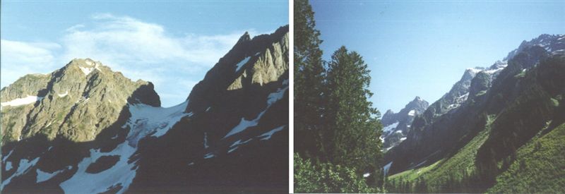
| That was minor bad news. The good new was that we found ourselves in Shangri-La – it was too dark when we arrived last night to see what a paradise we had hiked into. The Horseshoe Basin was about 500 to 1000 feet of steep cliffs with what looked like over a dozen cascading waterfalls pounding in a semi-circle before us. Topping that, a glacier-snow field extended to truly majestic peaks and torn up ridges. Minarets, etched to points and knife-edges spread from Mountain peak to peak. Problem was we could not find a direct correlation to the page from the Becky guidebook. It did look oughly tempting, but I was a bit reticent about the nasty climb from the lower to the upper basin and the description of the steep snowfield to Mt Buckner left me with some apprehension as well. The view was nevertheless persuasive and Jordon and I began to scheme as to a plausible plan and approach. Jordon was excited; I was determined. After a really great breakfast of blueberry pancakes (Thanks Jean!) sprinkled with our ever-present Tang, we packed our gear and proceeded up the valley and across the snowfield. We were just able to do it without crampons and we found a convenient bridge across the bergshrund to the cliff-face. A seemingly unending series of steep heather, stunted pine benches and short class 3 & 4 sections of rock and waterfall hopping were to be our lot for the better part of the day. After leading us up a few nasty | |
 |
paths that evolved into class 4 run out I found that Jordon was the superior route finder and I began to increasingly defer to his keen eye for a good route. A few places were too precarious; a ledge here, a waterfall crossing there. On those places we roped up and helped each other. |
 |
|
 |
Jordon Builds a bridge. |
| With a sweet waterfall at our side, we pulled out our lunch and recouped our strength. The rest of the cliff face rolled off a bit and we climbed up without much further danger. | |
 |
 |
| What we did have to contend with though was the brush and trees that blocked even our best route finding. Becky’s guide must have been written when the brush was much less developed. I looked at the snow dome in the lower valley below. Facing the mountain on the left of an old Goldmine shaft, the steep snowfield extended almost half way up the cliff reaching to where a short treed cliff face connected the upper and lower basins. The cliff appeared to be class 3 to the top and a short section at that. I determined that on the decent, we would try that route. It would be hard to be worse than the one we ascended! | |
 |
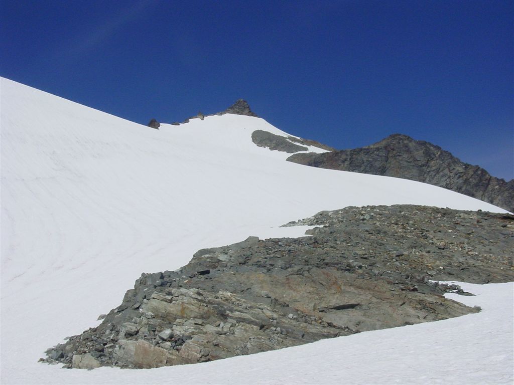
At about 3PM we topped out next to the glaciers’ snowfield.
|
 |
The Black horse flies were so bad, we quickly set up the tent and Jordon dove for cover. They didn’t have such an affinity for me so I cooked the spaghetti. It seemed to take a while and by dark we ate. Jordon and I took turns reading from the Book of Mormon and we sang a few hymns. Our prayers of gratitude that night were heartfelt. |
 |
|
Thursday: |
|
 |
 |
|
but we were so fried, that in actuality we barely left camp at 7 or so. Jordon and I each sported day-packs, ice-axes and crampons. Right away the snow steepened and became increasingly so. We had about 50 feet between us on the rope and we climbed in sync maneuvering from rock outcropping to outcropping. |
|
 |
Boy did that ever live up to it’s namesake. Crazily thin spires and jaggies 5 to 20 feet tall and etched thin and sharp.
|
| The other side dropped off like the edge of the earth to a huge and fractious Boston Glacier. It extended a few thousand feet below for about a mile below the Ripsaw back to Mt. Sahale, which now seemed a bit below us. | |
 |
|
We dropped off the crampons and worked our way
round to the right in the bergshrund and then up a nasty gully to a saddle
between the twin spires that I thought were the peaks.
I could see at this point though, that the highest peak was neither
of the twin spires we straddled, but a sloping mass farther and a ways
back and up to the right. It
was so odd that we could not see this perspective from any of our
observations.
 Real Peak is right of middle.
We were hardly crushed, though, as the spires were so challenging and spectacular in their own right. Jordon stayed out of the way as dozens of stoned rained down as I scrambled up the class 3-4 slot to the saddle. Jordon followed straightway up a short chimney section to the rubble heap making up the top of the saddle. I can tell you, it made for one awesome lunch stop. After filling up on jerky, gorp fruit and crackers, we began to select out a rack of climbing gear to scale the spire. It looked to be about 60 feet up and extraordinarily rotten. Yet there was a plausible and low class 5 route. Really the hard part was finding a hunk of decent rock to set a cam or wedge. I was lead-climbing so I donned to helmet while Jordon belayed me up the rubble. |
 This
stuff was so moth-eaten that in many places you could actually see through
major sections of rock to the Boston glacier a thousand feet or more below
– really wicked. Jordon
followed as I in turn belayed him to a small anti-node near the top. This
stuff was so moth-eaten that in many places you could actually see through
major sections of rock to the Boston glacier a thousand feet or more below
– really wicked. Jordon
followed as I in turn belayed him to a small anti-node near the top. |
 We
needed to contact a friend to help us solve the key problem since I had
locked Jean out of the house. We
were very happy to find 4 bars of signal strength on my cell phone.
It’s remarkable how far a signal can go from these heights.
We left a few messages and lastly Jordon made contact with his good
friend Angela. He asked her to unlock
the door. The amusing this is that Jean found the door locked with a note
taped to the latch which read, "Key under mat." We
needed to contact a friend to help us solve the key problem since I had
locked Jean out of the house. We
were very happy to find 4 bars of signal strength on my cell phone.
It’s remarkable how far a signal can go from these heights.
We left a few messages and lastly Jordon made contact with his good
friend Angela. He asked her to unlock
the door. The amusing this is that Jean found the door locked with a note
taped to the latch which read, "Key under mat." |
| Tethered on a small section of rope, each one of us in turn scooted out the narrow rib to the little knob that would be our mountain peak. It was so small; I had to push on it to make sure it would support me. We took our pictures, but unfortunately, we ran out of film so the remainder of the journey in only in our heads. |
|
|
|
Jordon tossed a few large stones down the precipice that actually shook the tower so I called a halt to that tradition. Jordon rappelled to the saddle 1st and I followed. I was a bit concerned about the rock scramble to the bergshrund, so Jordon did it under belay. It was fine so I proceeded behind him unprotected. This section of the snowfield was particularly steep. We wanted to glissade the couple of thousand feet, but for at least the 1st thousand, having very little experience sliding on the slopes, Jordon took the 1st leg spooling out the climbing rope. He looked great and in good control. The ice-axe belay anchor worked great, so Jordon planted for me an off I followed. Weeeeeee does not do justice! Wow, what a thrill. One after another, we leap-frogged each other; shooting down 300 feet at a time. Total jazz. Seriously cold bums I can assure you, but we were having too much fun laughing to feel the full extent yet. Near the bottom, as the slope ran out, Jordon began using the axe as an oar and the race was on. At the last, we ran down moonwalk style almost to our tents. It was now about 3PM or so. We had to break camp and traverse about a mile of heather, brush and many groups of undulating ravines. If I had to do it over I would have stayed a bit higher, taking a slightly longer route, but flatter and easier walking. The direct route we took led us to the far corner of the horseshoe basin cliffs. We had very little of the tall and formidable foliage we dealt with on the steep face on the climb up, but rough walking, slippery slopes and ravines made the going interesting but slower. We crossed several wide fast flowing streams and skated down or across snowfields. At last we came to an exposed rock section at the edge of the basin about 500 feet below a descending ridge making up Mt Sahale. Jordon wanted to save the big climb down and then the long hike back up the valley, 1500 feet, to the Cascade Pass. |
|
|
|
 |
The shaft branches at a room some ways in, but we turned back as the day was waxing long and dinner was yet to be prepared. We decided to camp on the nice flat tailings at he front of the mine looking out at the valley below. We ate a really scrumptious meal of tuna fettuccini, vegetables, chocolate and lemon pudding. We read from the Book of Mormon and sang a few hymns. It was really a special evening befitting a really great day. |
|
Friday: We left the snowfield at the base of the mine rather early and began the 3 or 4 mile hike down the valley and then back up to Cascade Pass. |
|
|
|
|
 |
The headwall of the valley consists of a long
string of switchbacks directly facing the rising sun. We held a strong
pace as I really wanted to make that grade before the full sun bore down.
We topped out at the pass at about 11AM. The pass is the crossroads of the area and we chatted in glowing tones about the exotic Horseshoe Basin with several teams of climbers and backpackers. We cooked up a hot soup lunch nicely recouping our legs but I can’t say the same for the shoulders. |
|
The last leg of the trip was a repeat in reverse of the trudge up on Tuesday; a nearly endless series of switchbacks. Emerging from the canopy, we poured out onto the parking lot presenting thousands of feet of cliffs waterfalls and glaciers across the valley. This trailhead was a spectacular conclusion in itself. |
 |
|
|
|
 This
would require attempting to climb the steep snowfield up from the base of
the Davenport Glacier where we had camped to the Sahale glacier on the
other side of that ridge.
This
would require attempting to climb the steep snowfield up from the base of
the Davenport Glacier where we had camped to the Sahale glacier on the
other side of that ridge.